Physical Address
60 Ekwema Cres, Layout 460281, Imo
Physical Address
60 Ekwema Cres, Layout 460281, Imo


Google expands AI wildfire tracking capabilities to Kenya and 16 additional countries.
This initiative aims to bolster community preparedness and safety as wildfires become an increasingly pressing concern worldwide.
The expansion of the Wildfire Boundary Tracker, an AI-driven tool, is particularly timely given the rising frequency and intensity of wildfires, which have been notably impactful in regions like Europe and Africa.
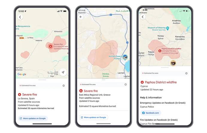
The Wildfire Boundary Tracker utilizes Google Search and Maps to provide real-time, accurate information regarding wildfire boundaries.
This innovative tool leverages advanced AI technology to analyze satellite imagery and various data sources, delivering precise information on the spread of wildfires.
Yossi Matias, Vice President and Head of Google Research, highlighted the company’s commitment to utilizing technology to enhance safety during natural disasters, emphasizing the importance of timely information for affected communities.
The United Nations Environment Programme (UNEP) has warned that wildfires are expected to become more frequent and intense due to rising global temperatures linked to fossil fuel combustion.
Africa, in particular, is significantly affected by this issue, accounting for 67% of the annual global wildfire toll.
In Kenya, wildfires have contributed to a notable 0.60% loss of tree cover between 2001 and 2023, with Global Forest Watch reporting 341 high-confidence fire alerts in the country as of 2024.
This data underscores the urgent need for tools like Google’s Wildfire Boundary Tracker.
The Wildfire Boundary Tracker is designed to send alerts to individuals in affected areas, providing crucial safety tips and guidance in multiple languages.
This feature is intended to complement existing emergency response efforts, offering an additional layer of protection for communities vulnerable to wildfires.
By equipping residents with timely and accurate information, the tool empowers them to make informed decisions during wildfire events, potentially saving lives and minimizing property damage.
The expansion of this tool includes a diverse range of countries across Europe and Africa, such as Andorra, Bosnia & Herzegovina, Bulgaria, Croatia, Cyprus, France, Greece, Italy, Monaco, Montenegro, North Macedonia, Portugal, Rwanda, Slovenia, Spain, and Turkey.
This broadening of the service reflects an increasing recognition of the need for innovative solutions to combat natural disasters, particularly in regions prone to wildfires.
The implementation of the Wildfire Boundary Tracker in Kenya holds particular significance due to the country’s vulnerability to wildfires and their subsequent impact on local ecosystems and communities.
The inclusion of Rwanda alongside Kenya in this expansion further highlights Google’s acknowledgment of the wildfire risks faced by African nations.
This initiative could pave the way for further technological interventions in disaster management across the continent, addressing the unique challenges posed by climate change.
As climate change continues to alter global weather patterns, the likelihood of extreme weather events, including wildfires, increases.
Tools like the Wildfire Boundary Tracker are becoming essential components of disaster preparedness and response strategies worldwide.
Google’s initiative exemplifies how technology can play a pivotal role in global efforts to combat natural disasters, offering a model for other tech companies to follow.
Read Next: Developing Countries Now Embrace Advanced AI Technology at a Faster Pace
As the Wildfire Boundary Tracker becomes available in more countries, its potential to save lives, protect property, and minimize environmental damage grows.
The multi-language support ensures that diverse populations can access vital alerts and safety information, making the tool more effective in reaching those who need it most.
Google expands AI wildfire tracking to Kenya and 16 other nations represents a significant advancement in disaster management.
By providing timely and accurate information, this tool not only enhances community preparedness but also reflects a broader commitment to leveraging technology for public safety.
As wildfires continue to pose a threat globally, initiatives like this will be crucial in developing effective response strategies and protecting vulnerable communities.
Was this information useful? Drop a nice comment below. You can also check out other useful contents by following us on X/Twitter @siliconafritech, Instagram @Siliconafricatech, or Facebook @SiliconAfrica.